The backstories to wetlands in drylands research sometimes may be told around campfires or over a drink or two at conference dinners, but rarely are written down. Here we provide an opportunity for researchers to tell us how they become interested and involved in wetlands in drylands science or management. What papers, talks or events have particularly inspired them? What continues to motivate them? Where is wetlands in drylands research going? On the back of his success at winning the 2020 South African National Wetland Award (see ‘Latest News’), in November 2020 we invited Spike McCarthy (University of the Witwatersrand, South Africa) to kickstart what we hoped would be a regular series of reflections from wetlands in drylands researchers or managers. Fred Ellery, one of Spike’s key collaborators from early days in the Okavango research programme and another doyen in wetlands in drylands research, then provided his contribution. Stephen Tooth, whose first major experience of a wetland in a dryland was a trip to the Okavango Delta with Spike and Fred, has also contributed. Other recent contributions have been made by one of South Africa’s foremost aquatic ecologists, Jenny Day, and by an early career researcher from India, Manu Singh.
—————-
Manu Singh , March 2025
How did I become a ‘wetlands in drylands’ (WiDs) researcher? Well, I can say that I kept choosing whatever path came in front of me first and kept walking, steadily, only to find myself here. But how did this journey start? I always wanted to be a scientist, even as a kid. I joined a BSc course in Hansraj College, Delhi University, in August 2008, thinking I would become a Computer Scientist (now we call them Data Scientists). By the 2nd year of my BSc, the limited available enrolments on my preferred pathway meant that I would not be able to pursue a Computer Science career, and Physics would be my pathway instead. I wanted to become either a Nuclear or Nano Physicist, but owing to various complications regarding the timing of BSc final year exams and MSc entrance exams, here too things did not work out as planned. So, in August 2011, I found myself doing an MSc in the Andaman Islands, learning Earth Sciences, specifically coastal disaster management at Pondicherry University, Port Blair. I started to like Earth Sciences, and sat for an all-India entrance exam (CSIR-UGC NET-JRF) in December 2012. This exam is a national eligibility test (NET) for lectureships and junior research fellowships (JRFs). I passed the NET with a JRF in Earth Sciences and got selected for a 5-year PhD fellowship. A professor at Pondicherry University, Dr S Balaji, asked which topic I wanted to do a PhD on. I come from Bihar, a state in India known for recurring flood hazards, and River Kosi is known as the ‘Sorrow of Bihar’. I replied to him that I wanted to do a PhD on Kosi floods and help my state “get rid of this hazard for good” (or words to that effect). He suggested that I write to Professor Rajiv Sinha at the Indian Institute of Technology Kanpur (IITK), who is known for his seminal works on tropical rivers and fluvial geomorphology. I wrote to him, and he encouraged me to apply for a PhD position in the Geosciences Division of the Civil Engineering Department at IITK. After an interview there, I was selected, and had a plan to work on flood hazards. But, again, things did not work out as planned.
One day, I met Prof Sinha for some administrative work, and asked him: “Sir, do you know why Kaabar Tal is drying?” Kaabar Tal is (was) the largest freshwater permanent wetland in the Ganga (Ganges) Plains, and just a few kilometres from my ancestral village. He replied: “Do you want to know why?” And my affirmative answer to his question is why I switched the focus of my PhD and became a wetland researcher.
But how did I become a wetlands in drylands researcher more specifically? As a part of my PhD thesis, I wanted to understand the geomorphic genesis of the Ganga Plains wetlands, some of which are located in dryland settings, but initially I was more focused on the humid settings. I found it extremely difficult to find works on wetland geomorphology, whether it be on Indian wetlands (negligible work) or on wetlands in other global regions (a few works). However, one name kept popping up: ‘Stephen Tooth’.
After defending my PhD thesis in December 2019, on the 3rd February 2020, I gathered the courage to write to Professor Tooth, asking for a postdoc with him. After a few paragraphs explaining my PhD work and skills, I wrote:
“Professor, you have been actively contributing to the domain of wetland hydrodynamics. Therefore, I wanted to ask if there is some research opportunity (preferably post-doc position) available with you for me.”
His reply was very encouraging. A line from his reply that I still remember was:
“I can see that there are many areas of overlap between my research interests and your own, although your GIS, remote sensing and spatial statistical skills will far outstrip my own.”
He asked where I would like to work and suggested that we write a postdoctoral fellowship proposal on wetlands in drylands. We decided to apply for the Royal Society Newton International Fellowship as the deadline was closest among other potential fellowships. However, due to COVID-19 lockdowns coming into force immediately after our initial email conversations, we decided not to develop the proposal because, even if successful, we would not have been able to undertake any fieldwork. Later that year, I was able to apply for the Alexander von Humboldt Postdoctoral Fellowship with Professor Bodo Bookhagen in Potsdam University, Germany. The proposal was accepted and I worked with him until October 2023. But during my time in Germany, Professor Tooth and I kept in touch. In November 2022, one year before my Humboldt Fellowship was about to end, I wrote to Professor Tooth again asking if he would be willing to support a Newton Fellowship application, to which he agreed. I told him that I would like to work on Indian arid regions and with the following research ideas:
“What are the spatio-temporal dynamics of the surface waterbodies of Indian drylands under changing anthropogenic pressure and climate variabilities? Maybe a research question with some societal implications of dryland wetlands? Further, let us pitch drylands regions as an indicator of environmental change (at a regional or maybe at a global scale changes) since they are most susceptible as well as sensitive to climatic and anthropogenic pressures.”
One key highlight from his reply was as follows:
“We should develop the idea of ‘sentinel wetlands’ …. those wetlands that might provide early warning indications of longer term changes.”
We started to write the Newton Fellowship proposal along those lines and submitted it in March 2023. In August of that year, we got the news that the proposal had been funded for three years, and I joined him at Aberystwyth University in the last week of November 2023. And with this move, I started my journey as a fully-fledged wetlands in drylands (WiDs) researcher.
I am writing this story on the 28th February 2025. It has been 15 months since Professor Tooth and I started working together on WiDs. We started with Indian drylands but seeing the success of our methods and utilising the other opportunities that came along, we have now expanded the work to a global range of WiDs. We have finished thousands of kilometres of road trips in the Indian and Argentine Patagonian drylands and visited hundreds of WiDs. From this work in India and Patagonia, as well as more focused work in Doñana National Park in southwest Spain, we have selected dozens of ‘sentinel wetlands’ so far. We still have 21 months left in this project and many kilometres (and other continents) still to go!

—————-
Jenny Day, August 2024
Like many students of my generation, I wanted to do medicine. I suppose I had a romantic notion of striding down long corridors in a white coat with a stethoscope hanging out of my pocket. In reality, however, I didn’t get a very good Matric and so I wasn’t accepted into first-year medicine. Like most of us in that position, I thought that if I did well enough in the first year of a BSc, I would then be accepted into medical school. That was true, but reality came to the fore once again: I really wasn’t a very good student and Medicine scorned my second application. Nothing daunted, I continued with the three-year BSc degree, again intending to apply to Medicine when I graduated. But something strange happened: I fell in love with science, and with invertebrate animals in particular. This was driven at least in part by the marine field trip we did to Langebaan in the Easter vac of our second year. What a mind-blowing experience! We dug in mud – and found worms; we searched the rocky shore – and found barnacles and crabs and snails and an immense array of tinier and completely unknown beasties, unknown to me at least. Back in the lab we dissected some of them, and found out how beautifully and cleverly they are constructed. To this day I would rather spend an hour marveling at the tiny lives revealed by a microscope than spend an hour watching lions stalking their prey. I really would. My new interests reawakened my academic abilities, which had been cowed by my obvious lack of progress at university. I did really well in third year, even though in Zoology it mostly covered vertebrates, including a lot of emphasis on bones from fish to mammals, and highly hypothetical analyses of potential evolutionary pathways. I also took a second year of Chemistry, which has stood me in much greater stead throughout my career. In Honours we had to do four (yes – FOUR) projects. One of mine was on the distribution of Cumacea (small shrimp-like benthic crustaceans) in False Bay, one was on the feeding mechanism of a local intertidal gastropod, Argobuccinum argus (now A. pustulosum) and a third on its production of sulphuric acid as a means of boring into the shells of its bivalve prey. The fourth was a biochemical study of the enzyme LDH (lactic acid dehydrogenase) in invertebrates. I mention all of these because they were all important for my future studies. As a result of my work on Argobuccinum I was invited to attend a symposium of the AAAS (the American Society for the Advancement of Science) in Dallas, Texas, where I presented my first conference paper (a truly scary experience for a young South African student abroad!) and which resulted in my first published paper. The LDH work led to me beginning an MSc on that enzyme. I later realised that the subject was far too sophisticated for the equipment and expertise we had in the Department (indeed in South Africa) at the time; I was greatly relieved when my supervisor resigned in order to emigrate to the USA and I also found out that I was pregnant (the two being entirely unrelated!), giving me two excellent excuses to abandon that impossible project. It also saved the lives of many octopuses, which were my study animal, and which I greatly admire. You will note that hardly a word has been said about ecology, let alone wetlands, and I suppose it’s true to say that I fell into both serendipitously. At about that time I became a Junior Lecturer in the Zoology Dept at UCT, and by now also had two small children, yet I decided to start a PhD project too. (I can’t for the life of me remember why I thought that that was a good idea at the time: I think “sucker for punishment” more or less covers it.) I needed a thesis topic that could co-exist with my duties as wife and mother and lecturer, and bethought me of the beautiful little critters of my Honours project: Cumacaea. So, I landed up doing a PhD on the taxonomy of several families of South African Cumacea. I loved those tiny beasties (hardly any of them more than a centimetre long), but the excitement of drawing and describing species after species soon began to pall. I eventually competed the thesis and looked about for something new to get my teeth into. And something serendipitous happened, once more. A colleague and friend, Jenny Jarvis, worked on naked mole rats in Namibia. There was unexpected rainfall during one of her field trips to the middle of the Namib Desert and Jenny noticed a pond by the side of the road. It was just a couple of meters across, and maybe 20 cm deep at most. But zooming around in it were remarkable little crustaceans that, had they been magnified a hundred times, would have convinced her that she was in Jurassic Park. There were shield shrimps looking like animated trilobites, fairy shrimps with gossamer gills and golden gonads swimming upside down beneath the surface film, clam shrimps in coitus, males holding females at 90 degrees in front of them and using them as battering rams, to say nothing of even smaller ostracods and copepods, their tiny movements adding a shimmer to the water. Jenny was entranced, but more importantly she thought of my interest in crustaceans. So, she collected a whole lot of individuals, which now became inanimate specimens. On her way past the area on her return home, however, she noticed that the pond had entirely disappeared, and that the soft bottom sediments held some tiny corpses. To her eternal credit, and to my delight, she collected some of that dry sediment. When she returned to UCT, she gave me one of the best and most important presents of my life: a few dead crustaceans, and a small bag of dry mud.  A shield shrimp from a temporary pond (attribution: Wikimedia Commons, Rise 0011). Well, that’s how my interest in inland waters, and wetlands, and ecology all started. I put the dry mud into a plastic lunchbox, added water, and waited. Within a day or two, larvae were buzzing around the “aquarium” and within a week, there were the shield shrimps and fairy shrimps and clam shrimps and ostracods and copepods. What biologist could fail to be intrigued by this amazing demonstration of adaptation in the form of crustaceans, quintessential aquatic organisms, surviving complete desiccation? (As an aside, these fairy, clam and shield shrimps are all primitive crustaceans belonging to the primitive crustacean class Branchiopoda. If you want to read more about their remarkable biology, download Vanishing Waters – see reference list.) I didn’t morph from marine biologist to freshwater ecologist overnight, but I did become more interested in inland waters. I also realised that the term “fresh waters” isn’t always appropriate – many ponds and lakes throughout the world are brackish and some are even hypersaline. At the time, I shared an office with another good friend, Jackie King. She had just started her PhD on Black Duck in the Eerste River, so was becoming very familiar with the freshwater invertebrates that live in rivers. (Don’t forget that my background was entirely on marine inverts.) We became the freshwater “experts” in the Zoology Department, which shows how very little expertise there was in the department at the time. (Horrendously, when the Zoology and Botany Departments merged some years ago, freshwater ecology once again disappeared and is still not studied at UCT, to the University’s eternal shame.) Jackie and I were soon confronted with the reality that many freshwater ecosystems in the vicinity of Cape Town were in very poor condition and were threatened by dams, and pollution, and alien invasive plants and animals – the same issues that confront them today. So, if we wanted to study “pristine” rivers and wetlands, we would have to join hands with water managers and assist in the conservation and management of our favourite rivers and wetlands. We both took on this responsibility, if not with enthusiasm then certainly considering it to be our duty (although we didn’t think in such elevated terms at the time!). Jackie became a world expert in river management, ultimately winning the aquatic equivalent of a Nobel Prize – the Stockholm Prize for water management. I became an academic in the Zoology Department at UCT, eventually paying the price of seniority and becoming Head of Department for some years, and Deputy Dean of Science for nearly a decade. On the freshwater front, Bryan Davies and I developed a semester-long third-year course in freshwater ecology, which was very popular and which generated quite a few freshwater professionals. I enjoyed lecturing to undergrads but my postgrads were a joy and an inspiration. The Zoology Department’s Freshwater Research Unit (FRU) became the premier institute for freshwater ecology in the country for more than 20 years. I hope that my PhD students who are now academics at other South African universities will succeed in reviving FRU in another manifestation.
  Jenny and PhD students in the Rondegat River in the Cederberg. On the research front, my students and I worked on rivers and wetlands in the Cape, trying to do some “proper science” despite a lack of funding for anything not considered to be of practical value. In the early days I was able to expand my interest in those little Namibian goggas, and spent quite a lot of time on field trips in the Namib, followed by lab work during term time. My love for those beasties has never left me, but logistics and finances meant that I was unable to concentrate on them. Instead, I have become more involved in water management, particularly in relation to water quality and to the conservation of biodiversity.
  Jenny and students investigating a tiny temporary trickle full of shield shrimps in the Tankwa Karoo. Looking back, I can see how lucky I have been as an academic and a professional aquatic scientist. I have taught and supervised a host of wonderful students; I have had the opportunity to work all over the world, particularly in southern and eastern Africa; I have visited remarkable rivers and wetlands and have had the privilege of contributing to their management and conservation, working with passionate and dedicated ecologists and ecosystem managers. I recently revised a book, Vanishing Waters, on management and conservation of Africa’s inland waters. (The first two editions were co-authored by the late Bryan Davies). Hard copies are available free of charge (within South Africa only) by e-mailing Lani van Vuuren at laniv@wrc.org.za, giving your street address for couriering purposes. The e-version can be downloaded from the Water Research Commission’s website, reference number SP 160/23. The full reference is: Day JA & BR Davies 2023 (3rd ed.) Vanishing Waters, Water Research Commission, Pretoria, South Africa, 522 pp. Download Part 1: https://www.wrc.org.za/mdocs-posts/vanishing-waters-third-revised-edition-part-1/ Download Part 2: https://www.wrc.org.za/mdocs-posts/vanishing-waters-third-revised-edition-part-2/
—————-
Stephen Tooth, October 2021
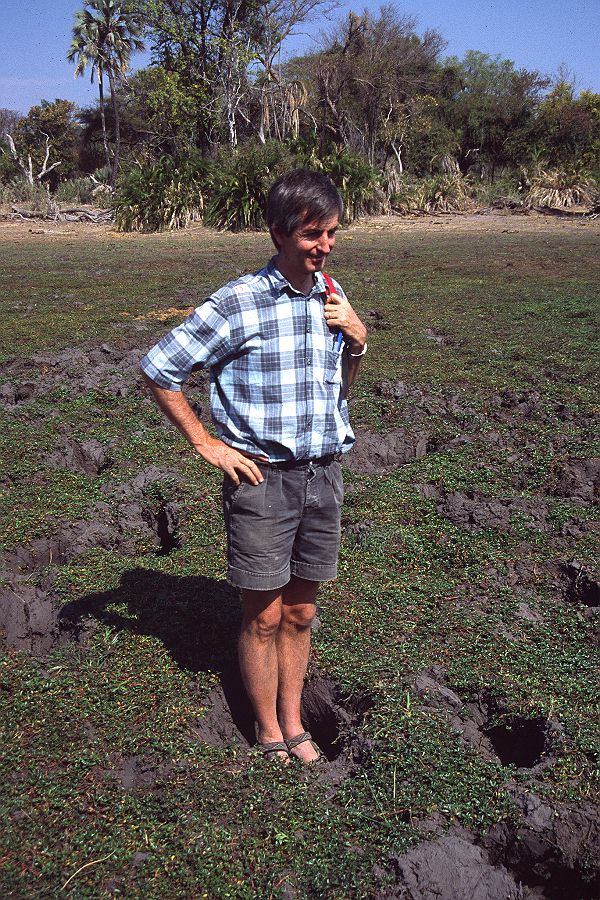
On the back of presenting a Keynote Presentation at the 2021 National Wetlands Indaba – held this year in virtual form – I have finally forced myself to put into words how I got started in wetlands in drylands research. My contribution follows on from the previous excellent contributions to this ‘WiDs Reflections’ series by Spike McCarthy and Fred Ellery, for reasons that shall become obvious. Very early days: My story goes back to the start of my postdoctoral research in the late 1990s at the University of the Witwatersrand (hereafter Wits) with Spike. In the early-mid 1990s, I had undertaken PhD research at the University of Wollongong and investigated the forms, processes and the late Quaternary history of dryland rivers in central Australia. I completed my thesis, which included an extensive review of previously published dryland rivers research, all without the word ‘wetland’ really featuring. I cited some of the Okavango work undertaken by Spike and others but this river system seemed like an oddity, worth mentioning only because it was so different to most other dryland rivers worldwide. This remains partly true today: the Okavango is indeed highly unusual. But what I and most other geomorphologists publishing before me had missed, or had failed to document sufficiently, was that a significant number of dryland rivers are associated with wetlands, albeit ephemeral or seasonal ones, and that drylands more generally can contain many non-fluvial types of wetland. In September 1997, I presented some of my PhD findings at the 6th International Conference on Fluvial Sedimentology in Cape Town. I am grateful for the fact that my PhD supervisor (Gerald Nanson) had the funding to pay for me to attend that meeting, as it turned out to be a life changer in many ways, both professionally and personally. Here, I met Spike for the first time, and over the week we struck up conversations about rivers that terminate in floodouts and many other related fluvial topics. I knew very little about African geomorphology, and while I had long thought it would be fun to travel the continent, never really thought it would happen. Full of ideas for projects, including those related to ‘rivers of diamonds’, Spike tried to persuade me to come to South Africa to undertake postdoctoral research. I’ll be honest: for various reasons, a postdoctoral placement in South Africa was not my first choice but over the following year, other options did not work out and, in the end, I decided to give it a go. Still early but slightly later days: Spike helped secure me a National Research Foundation (NRF) Postdoctoral Fellowship and after a protracted process to acquire the necessary visa (a long story related to administrative uncertainties in the early post-apartheid era), I arrived in South Africa in September 1998. The main purpose of the fellowship was to investigate alluvial sediments along some of South Africa’s interior rivers. Palaeoanthropologists and archaeologists had been discovering fossil faunal assemblages and archaeological artefacts in sediment exposures in extensive gully systems (locally termed ‘dongas’) throughout large areas of the Free State in particular, but needed someone to document the sedimentology, interpret the fluvial dynamics, and infer the palaeoenvironmental conditions. Wetlands weren’t really supposed to be a major focus. But a couple of days after arriving in South Africa for just the second time, I found myself flying up to Botswana with Spike and Fred Ellery to do some of their consultancy work at tourist camps in the Okavango Delta. This work involved finding locations for soakaways to safely deal with overflow from the septic tank systems. What a trip. Over 4 or 5 days, we were flown in light planes across the Delta between various camps (I still use the photographs that I took in my presentations today), and we stayed in accommodation normally reserved for guests who pay hundreds of US dollars a night for the privilege. Five minutes after landing at the first camp, we all went for a short walk, and startled a young elephant browsing just a few metres away in the bush. I’ll never forget the sound of that trumpet at close quarters … and how all of us scattered in different directions to get away. No harm was done but my African bush senses were definitely elevated. In between doing the actual work – augering holes and topographic surveying of groundwater levels – we went on game drives and saw just about every large animal possible to see, short of lion. [Mind you, there had been reports of lions padding through one of the camps at night, which had added a certain frisson to the night walk through the bush from the dining area back to the accommodation, especially for a young Englishman]. Some of the most memorable sightings included a leopard hanging out on a tree branch just a few metres away from where we had stopped our vehicle (to this day I have not had a better sighting of such a creature) and a honey badger that had been terrorising one of the camps and had clawed at the camp manager (or forced him to fall into a thornbush in an attempt to escape …. I forget which, but either way the manager had large scratches across his face). At the end of each day, we had the obligatory sundowners and ate some of the best food with the wealthy guests. Obviously, Spike and Fred talked at length about the processes shaping the delta and I tried to join in, but really I felt I had little to offer. They knew the system so well, had published extensively on more than a decade’s research, and initially I just couldn’t see what I could really contribute from my understanding of Australian dryland rivers. As it turned out, there were at least two lines of investigation where ultimately I was able to make a contribution: working out the reasons for the downstream transition from meandering to straight channels, and starting to address the chronology of channel change in the Delta. But that’s a different story, only partly returned to below. The point here is that this was my first exposure to a wetland in a dryland but at the time it just seemed to be a novelty trip.
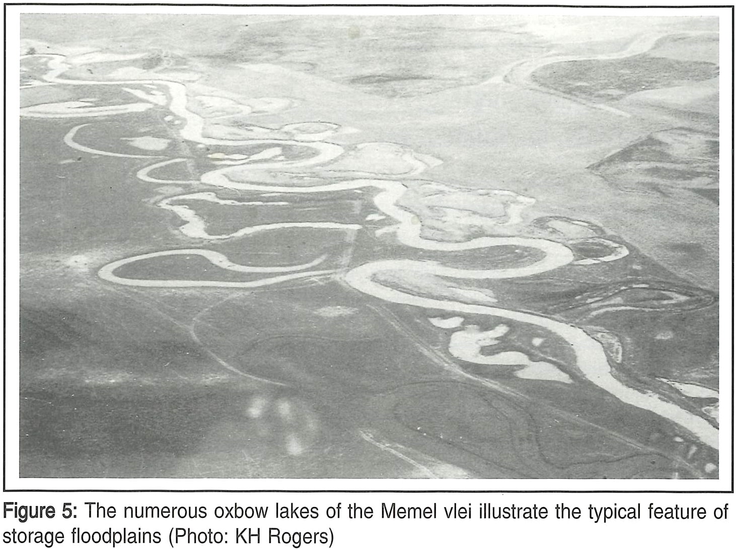
After we returned to South Africa, I tried to settle down and get my head around the published literature on South African geomorphology and Quaternary environmental change, something more in line with the Postdoctoral Fellowship brief. This was daunting: having previously worked on rivers draining the essentially base levelled, largely tectonically inactive, Australian interior, I just wasn’t attuned to the complexities of fluvial processes on the uplifted, high elevation, southern African subcontinental interior. I took various trips to fossil-rich alluvial successions exposed in dongas in the Free State and puzzled over how to integrate the observations. I took another trip around Botswana with Lee Berger (a Wits palaeoanthropologist) and several other people during which we looked for fossiliferous sites in the Kalahari. This trip (which turned out to be an infamous one, for various reasons that would require another few thousand words to explain) included a visit to the extensive saline flats of the Makgadikgadi Depression (e.g. Jack’s Camp) but I didn’t really think of these features as a type of wetland in dryland, despite the fact that they would actually be included in many wetland inventories. I kept reading, gradually getting used to the complex and sometimes changing place names across the subcontinent. I combined this with many weeks’ work that involved pouring over hard copies of 1:250 000 scale topographic and geological maps to extract the long profiles of the Orange River and key tributaries from the contours, and then matching any interesting changes to the underlying geology. [For the amusement of younger readers, this was done in pre-Google Earth days and before any appropriate digital datasets were available, so given that the Orange R is over 2000 km long, was undertaken with large sheets of tracing paper, a pencil and eraser. The sheets were then sellotaped together before the tracings of the river between the contours were laboriously measured with a map wheel. Distance and elevation values were then entered into a Cricket Graph spreadsheet for digital plotting on a first generation Apple Mac laptop]. One day, while taking a break from this fairly tedious but ultimately informative work, Spike showed me a black-and-while oblique aerial photograph of the meander belt of the Klip River near Memel (Seekoeivlei). This photograph was in Kevin Roger’s ‘Riparian wetlands’ chapter in Cowan’s (1995) edited ‘Wetlands of South Africa’ book. He said something to the effect of “Why are these meanders here? We have to investigate this”.
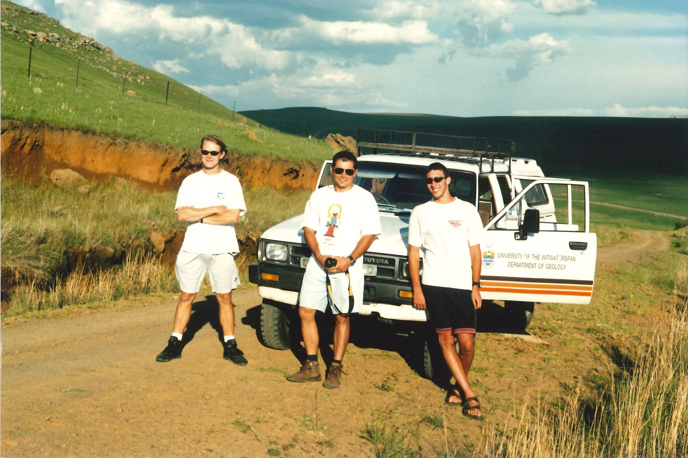
Initially, I didn’t think it was a very interesting question. You can find many meander belts worldwide that look just like the one at Memel. The Klip didn’t appear to be in a dryland setting – the Klip valley looked too vegetated and the river appeared to have permanent flow – and there were no dongas that might indicate exposures of fossil-rich alluvial sediments. How was this relevant to the postdoctoral research? For additional reading, Spike gave me a collection of papers on wetlands – published in a 1995 special issue of ‘Vegetatio’ – but for someone with my background this was pretty hard going, with most papers just focusing on ecology-based wetland classification and inventory. As a geomorphologist, how was I supposed to make any contributions to this field? Even Spike’s preliminary air photo geomorphological mapping of the river system neighbouring the lower Klip valley – the formerly meandering but now incised Schoonspruit with its dongas – didn’t really seem all that interesting. A short field trip to look at the fossil faunal and archaeological artefacts emerging from the Schoonspruit dongas didn’t seem to add all that much to my interest. At that time, I was more interested in looking at river systems farther west. In parts of arid western South Africa and Namibia, you had ‘proper’ dryland rivers: rivers that were ephemeral, poorly vegetated, and rarely associated with wetlands. With my PhD research on Australian anabranching systems fresh in my mind, I had also noticed on the topographic maps – seemingly for the first time – the extensive and very unusual bedrock anabranching pattern of the Vaal River at Parys and the Orange approaching Augrabies. Surely, these were more worthy of investigation? [These observations did in fact form the basis for later projects, but again, this is another story]. I don’t know whether Spike detected my initial lack of enthusiasm for addressing the questions surrounding the Klip and Schoonspruit, but if he did, he decided to counter it by not letting the questions drop. “Why are these meanders here?”. To expand: why is there an extensive meander belt along a valley deep in the interior of an uplifted continent that is undergoing long-term denudation? And why are the river reaches immediately upstream and downstream of Seekoeivlei so much straighter? Looking at the relevant geology map provided a quick and easy answer to that second question. Where dolerite cropped out at on the river level, the river followed a relatively straight course but where the river flowed over sandstone or shale, the river was far more sinuous. We put a Wits Geology Honours student (Ryan Morris) onto the project and in mid December 1998, myself, Ryan, Dion Brandt and John Hancox drove down to Memel for a weekend of field investigations. Within a few hours of driving around the area for a ‘look see’, we had confirmed what we suspected from the geology maps. We did topographic surveys, augered holes and collected sediment samples from the channels and floodplain to characterise the fluvial geomorphology more closely, and pondered just why the river form would change so dramatically as it transitioned from one rock type to another.
In time we worked that puzzle out and ultimately published the findings (ref. 1). The ‘hard rock barrier’ model of meander belt and floodplain wetland development was a key conceptual advance that helped with the understanding of many other South African interior floodplain wetlands. Many other floodplain wetlands either conform to this model or, if they differ, can be explained as a consequence of hard rock barrier breaching. Barrier breaching results in deep channel incision, which leads to floodplain wetland desiccation, donga formation, and exposure of alluvial and valley-margin colluvial sediments. The Schoonspruit – previously uninteresting – provided a key part of the evidence base for the latter situation. Ultimately, the alignment of these pieces of the puzzle led to another key paper (ref. 2) and the platform for much later research (e.g. refs. 3, 4). But the more relevant point here is that my interest in wetlands in drylands had been well and truly lit. With other Honours students (Elizabeth Nortje and Kate Buckley), we had also been investigating Nylsvlei (ref. 5), which provided interesting similarities and differences with the Klip and Schoonspruit, and also provided the platform for later research in this part of South Africa (e.g. refs. 6, 7, 8, 9). Even the alluvial sediments exposed in dongas in the drier parts of the central Free State contained fossil fauna associated with wetter conditions than at present, and in effect represented palaeofloodplain wetlands. The demise of these floodplain wetlands in the change to the deeply incised, donga-rich, present-day systems could be explained as a result of barrier breaching and long-term climate change. Some of this work took a long time to come to fruition but eventually it too was published (refs. 10, 11). Later days still: So there we go: that’s my short(ish) summary of how I became involved with wetlands in drylands research. Many of the key conceptual advances were made during my Postdoctoral Fellowship at Wits in the late 1990s and early 2000s but with my appointment at Aberystwyth University in 2000, the work was able to continue and expand in scope. In particular, through collaboration with Geoff Duller and others, it was the application of optically stimulated luminescence (OSL) dating to floodplain wetlands sediments – starting with Helena Rodnight’s PhD research from 2002/2003 onwards – that proved to be another game changer. Successful application of OSL dating to systems like the Klip and Schoonspruit (refs. 12, 13) provided proof of concept for application to other similarly-scaled but interestingly different South African wetlands such as the Nyl/Mogalakwena, Blood River, Mooi River, and Tshwane River (e.g. refs. 3, 4, 7, 9, 11). We have also now successfully applied the technique to the even more challenging wetlands in northern Botswana: the Okavango Delta and Chobe-Zambezi floodplain wetlands, with papers forthcoming. This line of wetland research has been supplemented by some limited radiocarbon dating and cosmogenic isotope analyses (e.g. ref. 14) that has also provided key findings. But even by 2004 or 2005, Spike and I were confident enough to recognise that we had enough new insights to synthesise our findings into a global review of wetlands in drylands research, and we drew out the distinctive features of these environments when compared to the better studied, better publicised humid-region wetlands (ref. 15). Reflections: So, to complement Spike’s and Fred’s reflections, what lessons have I learnt along the way? First, there’s the importance of keeping an open mind as to what forms an interesting research problem. Kudos to Spike becoming interested in the Klip River ‘problem’ and badgering me to get interested in it too. The Klip isn’t your ‘classic’ type of dryland river, but all the more interesting for it ….. these more subhumid to semiarid types of system enrich our global understanding of the diverse range of dryland river characteristics, particularly by providing the opportunity to interlink the somewhat disparate dryland and wetland fields of research. Spike once said that we were “developing a new science of fluvial wetlands” and we both laughed at the hubris, but he also had a point. As I sort-of-said above, the empirical findings and conceptual advances related to this particular South African interior river have provided the platform for understanding the forms, processes, and behaviours of many other wetland-associated rivers, and not just in South Africa. The OSL dating work – done in combination with Geoff Duller and our students, postdocs and collaborators – has helped to demonstrate the applicability of the technique to fluvial sediments more generally, and has contributed greatly to the improved general understanding of the rates and timing of different fluvial dynamics (e.g. lateral migration, avulsion, incision, aggradation), and the relative importance of intrinsic and extrinsic drivers of those dynamics, including palaeoclimatic changes. Second, my story emphasises what Spike and Fred have already said: namely, the value of cultivating the conditions for curiosity-driven research. While my curiosity was not initially fully aligned with that of Spike’s, it did lead me to read more widely and deeply about bedrock-influenced river systems, which in turn allowed me to develop the hard rock barrier model of meander belt and floodplain formation. In turn, recognition of the possibilities of barrier breaching through hydraulic plucking and abrasion helped to explain the reasons for deep incision and donga formation along other rivers, including those that used to have fully functioning floodplain wetlands but now no longer do. The combination of Spike’s management style, the NRF Postdoctoral Fellowship and various lines of funding, particularly from the Skye Foundation, provided me with the freedom to follow that curiosity. Many different pieces of the initially scattered jigsaw puzzle eventually came together to form a more complete – but still nowhere near fully complete – picture of southern African fluvial landscape development. Third, and related to the above, is that curiosity-driven research may, just may, eventually have practical application and so be seen as ‘useful’ or ‘relevant’ in ways not initially anticipated. In a separate blog post, I have already commented on this point in relation to some of my seemingly esoteric PhD research on central Australian dryland rivers, and how decades later mining companies are now using some of this research to guide rehabilitation efforts for impacted rivers (see https://stephentooth.wordpress.com/2020/06/06/placing-geomorphology-in-the-public-domain/). In the case of South African wetlands in drylands research, the applications are perhaps more obvious. With recognition, albeit belated, of the importance of wetlands for ecosystem service delivery, there has been a move over the last few decades to rehabilitate and restore wetlands degraded by human activities. This includes the Klip River wetlands, for artificial channel straightening and drainage of part of the wetlands early in the last century had kickstarted a series of headward-eroding gullies. By the end of the last century, one of these gullies had evolved into a potential channel avulsion that was threatening many of the ecosystem services in these Ramsar-listed wetlands. Early management attempts had been only partially successful, and in the first decade of the new millennium there was debate over the best management options for addressing the problem. As we have documented (ref. 16), these options ranged from doing nothing to hard structural interventions (e.g. construction of more weirs). The details are not important here, but the key point is that our previous topographic surveys, sediment analyses, and OSL dating work had been done for curiosity’s sake alone but then proved invaluable for assessing the practicality and desirability of those management options. In particular, our findings ruled out the ‘do nothing’ option if the key aim was to restore some form of hydrological functioning to the wetlands. Just as the early curiosity-driven research in the Okavango by Spike, Fred and others had laid the groundwork for siting soakaways and developing other sustainable utilisation principles, our ‘blue skies’ research turned out to be ‘applicable’. And this really brings me full circle. As part of my keynote at the National Wetlands Indaba, I summarised the Klip River wetlands geomorphological and OSL dating work and how this had helped to provide a firm evidence base to assess the different management options. The broader point was that this something we need to think very carefully about as we ponder our management options in a putative Anthropocene time interval where many – perhaps most – wetlands in drylands are subject to varying forms of human intervention, and hard decisions about rehabilitation, restoration and other forms of intervention need to be carefully made. Consequently, I was gratified to read at least one positive comment in the online Chat after the talk: “Amazing talk. What really stands out for me is the importance of hydrological and geomorphological chronology data in order to properly run management scenarios and thus select the preferred man.[agement] option linked to the ecosystem services required.” So if my keynote has introduced at least one additional person to the value of our brand of ‘wetland in dryland’ science then, as far as I’m concerned, that’s a success. References cited:
- Tooth, S., McCarthy, T.S., Brandt, D., Hancox, P.J. and Morris, R. (2002), Geological controls on the formation of alluvial meanders and floodplain wetlands: the example of the Klip River, eastern Free State, South Africa, Earth Surface Processes and Landforms, 27, pp.797-815 (DOI: 10.1002/esp.353).
- Tooth, S., Brandt, D., Hancox, P.J. and McCarthy, T.S. (2004), Geological controls on alluvial river behaviour: a comparative study of three rivers on the South African Highveld, Journal of African Earth Sciences, 38 (1), pp.79-97 (DOI:10.1016/j.jafrearsci.2003.08.003).
- Keen-Zebert, A., Tooth, S., Rodnight, H., Duller, G.A.T, Roberts, H.M. and Grenfell, M. (2013), Late Quaternary floodplain reworking and the preservation of alluvial sedimentary archives in unconfined and confined river valleys in the eastern interior of South Africa. Geomorphology, 185, pp. 54-66 (DOI: 10.1016/j.geomorph.2012.12.004).
- Tooth, S., McCarthy, T.S., Rodnight, H., Keen-Zebert, A., Rowberry, M.D. and Brandt, D. (2014), Late Holocene development of a major fluvial discontinuity in floodplain wetlands of the Blood River, eastern South Africa, Geomorphology, 205, pp. 128-141 (DOI: 10.1016/j.geomorph.2011.12.045).
- Tooth, S., McCarthy, T.S., Hancox, P.J., Brandt, D., Buckley, K., Nortje, E. and McQuade, S. (2002), The geomorphology of the Nyl River and floodplain in the semi-arid Northern Province, South Africa, South African Geographical Journal, 84, pp.226-237.
- McCarthy, T.S., Ellery, W.N., Backwell, L., Marren, P., de Klerk, B., Tooth, S., Brandt, D. and Woodborne, S. (2010), The character, origin and palaeoenvironmental significance of the Wonderkrater spring mound, South Africa, Journal of African Earth Sciences, 58 (1), pp.115-126 (DOI: 10.1016/j.jafrearsci.2010.02.004).
- McCarthy, T.S., Tooth, S., Jacobs, Z., Rowberry, M.D., Thompson, M., Brandt, D., Hancox, P.J., Marren, P.M., Woodborne, S. and Ellery W.N. (2011), The origin and development of the Nyl River floodplain wetland: trunk-tributary river interactions in a dryland setting. South African Geographical Journal, 93 (2), pp.172-190 (DOI: 10.1080/03736245.2011.619324).
- Larkin, T., Ralph, T.J., Tooth, S. and McCarthy, T.S. (2017), The interplay between extrinsic and intrinsic controls in determining floodplain wetland characteristics in the South African drylands, Earth Surface Processes and Landforms, 42 (7), pp.1092-1109 (DOI: 10.1002/esp.4075).
- Larkin, T., Tooth, S., Ralph, T.J., Duller, G.A.T., McCarthy, T.S., Keen-Zebert, A. and Humphries, M.S. (2017), Timescales, mechanisms, and controls of incisional avulsions in floodplain wetlands: insights from the Tshwane River, semiarid South Africa, Geomorphology, 283, pp.158-172 (DOI: 10.1016/j.geomorph.2017.01.021).
- Lyons, R., Tooth, S. and Duller, G.A.T. (2014), Late Quaternary climatic changes revealed by luminescence dating, mineral magnetism and diffuse reflectance spectroscopy of river terrace palaeosols: a new form of geoproxy data for the southern Africa interior. Quaternary Science Reviews, 95, pp.43-59 (DOI: 10.1016/j.quascirev.2014.04.021).
- Tooth, S., Hancox, P.J., Brandt, D., McCarthy, T.S., Jacobs, Z. and Woodborne, S.M. (2013), Controls on the genesis, sedimentary architecture, and preservation potential of dryland alluvial successions in stable continental interiors: insights from the incising Modder River, South Africa, Journal of Sedimentary Research, 83 (7), pp. 541-561 (DOI: 10.2110/jsr.2013.46).
- Rodnight, H., Duller, G.A.T., Tooth, S. and Wintle, A.G. (2005), Optical dating of a scroll-bar sequence on the Klip River, South Africa, to derive the lateral migration rate of a meander bend, The Holocene, 15 (6), pp.802-811 (DOI: 10.1191/0959683605hl854ra).
- Rodnight, H., Duller, G.A.T., Wintle, A.G. and Tooth, S. (2006), Assessing the reproducibility and accuracy of optical dating of fluvial deposits. Quaternary Geochronology, 1, pp.109-120 (DOI: 10.1016/j.quageo.2006.05.017).
- Keen-Zebert, A., Tooth, S. and Stuart, F.M. (2016), Cosmogenic 3He measurements provide insight into lithologic controls on bedrock channel incision: examples from the South African interior, Journal of Geology, 124 (3), pp.423-434 (DOI: 10.1086/685506).
- Tooth, S. and McCarthy, T.S. (2007), Wetlands in drylands: key geomorphological and sedimentological characteristics, with emphasis on examples from southern Africa, Progress in Physical Geography, 31 (1), pp.3-41 (DOI: 10.1177/0309133307073879).
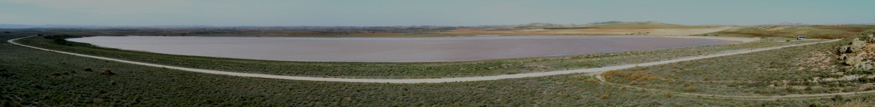
- McCarthy, T.S., Tooth, S., Kotze, D.C., Collins, N., Wandrag, G. and Pike, T. (2010), The role of geomorphology in evaluating remediation options for floodplain wetlands: the case of Ramsar-listed Seekoeivlei, eastern South Africa, Wetlands Ecology and Management, 18 (2), pp.119-134 (DOI: 10.1007/s11273-009-9153-7).
—————-
Fred Ellery, February 2021
Introduction What a privilege to be asked to write this piece. It is the second reflection in what I hope will be a useful compilation recording the birth and growth of an exciting branch of wetland science in which wetlands in drylands are better understood and (hopefully) managed. In the first piece in this series, Terence McCarthy spoke about the “day of wonders”, which my wife, Karen and I were part of. I’d like to flesh out that story a little. Kevin Rogers, the supervisor of our Masters Degrees, organized a trip to the Okavango with Charles Breen and Terence McCarthy, and our job was to host this trio for a week – what a daunting prospect it was for us! We had arranged a trip of about 100km in a boat, to visit active and abandoned channels (the latter not in a boat), lakes, islands and backswamps. The day that Terence recalls followed a dangerous but interesting walk to the abandoned Nqoga Channel across a several kilometres-wide ash-covered and featureless plain in which we encountered a large herd of curious buffalo. Remarkably, the bed of the abandoned Nqoga River rose 1.5 to 2 m above us! That evening, between telling me how to make a fire so we could prepare supper, Terence, Charles and Kevin sat beneath a gas light looking at aerial photographs and talked about what we had seen that day and, in the trip, that far. The observations we had been thinking and talking about all week started falling into place that evening and many research questions were planted that led to discoveries over a period of over 20 years. These seeds grew and metamorphosed, through the involvement of Stephen Tooth in particular, into the field of wetlands in drylands. As a young person I had travelled through the arid Kalahari to the Okavango Delta with a school group and was struck by the presence of this large wetland wonderland in such a dry place. I travelled there again on a field trip in my Honours year and met a local botanist, Pete Smith, who spoke about some of the key scientific problems in the system, the most curious of which was the decade-to-century switching of major distributary channels. There were several competing theories, one of which was that earth movements associated with earthquakes precipitated switching events. Another was that the hunting of hippo had limited the ability of these large animals to keep channels open. A third idea was that the plant papyrus was thought to encroach into newly formed channels and restrict their flow. My training as an ecologist in the Botany Department at Wits University presented an opportunity through Professor Brian Walker, to complete a Masters Degree on the role of the giant sedge Cyperus papyrus in channel blockage and abandonment. In collecting data about this I realised that papyrus encroachment into channels was limited by current velocity, and on a brief trip home I went to visit the Geology Department at Wits and spoke to their resident sedimentologist, Dr Tony Cadle, who shed light on this hunch. That was as far as that discussion went until Kevin Rogers organized the field trip with Charles and Terence that we hosted. Meetings with giants There is seldom opportunity these days to spend time in the field and in discussion with seasoned scientists who are passionate and curious about the world in which they live and work. I learned on the trip with Kevin, Terence and Charles that a good understanding of theory is central if one is to shed meaningful light and develop new insights. Such understanding guides careful and critical observation, which underpins careful measurement and analysis. These formative meetings with giants were central in my own development as a researcher. The association I developed with Terence was particularly important as he always saw the big picture and could carefully analyse and argue a perspective, and also embrace new ideas. We often think of giants in terms of seniority, but I have met many young people who have embraced what I and my peers do with curiosity and enthusiasm – answering questions that are beyond their station. I met Stephen Tooth as a young postdoctoral student and he stood out head and shoulders above his peers. Tim Ralph strikes me in a similar way, and when I read their work and that of their students. Michael and Suzanne Grenfell have shown their ability to embrace big ideas and build new knowledge carefully. Marc Humphries, Ryan Edwards and my older son, Steven, have also dealt with challenging problems as senior postgraduates and continue to build on these experiences. Simon Pulley and a cohort of students working in the Krom have also risen to answer fascinating questions. Relocations and re-invention as key to developing new interests The birth of our first child made Karen and I re-evaluate our priorities as a family and we moved to Durban where I took up a post in the Department of Geography and Environmental Science at the University of Natal (Durban Campus). It was an amazing Department that was based on a shared vision of teaching, learning and research. I thrived in that environment and saw it as an opportunity to apply much of what I had learned in my time at the University of Witwatersrand and in the Okavango. It led me to working in the Mkuze and Mfolozi Floodplains where the key question was to try and understand whether our discoveries in the Okavango were because it was “unique” in that the source of water was primarily from a large and distant catchment and evapotranspiration was the primary means of water loss. Although the details were different, what we had learned in the Okavango held in these two large floodplains as well. The formative work of many who had worked in the Okavango had led to a new way of thinking about wetlands! When I re-located to Grahamstown/Makhanda in 2008, there were very few wetlands nearby and certainly no large wetlands. This move allowed me to re-invent my interests in wetlands as an integral part of landscapes. I started by developing an interest in depressions on the African Erosion Surface, which forms a vast plain just outside Makhanda. More recently I have worked in the Krom and asked questions about how a broad valley with a horizontal cross section of up to about 200 m and a longitudinal slope of less than 1 % could form in the dramatic Tsitsikamma and Kouga Cape Fold Mountains. This has led me to seriously start rethinking the wetland restoration approaches of practitioners, and I have come full circle to focusing on the role of plants in shaping waterways. My last two years as a member of staff at Rhodes will be spent studying the regeneration ecology of the iconic plant “palmiet” (Prionium serratum) and considering its possible use in wetland restoration in unchanneled valley-bottom wetlands in the Cape Fold Mountains. Thinking about what is important in what we do I love everything about what I do at home and at work and have a very rich life. For me the most meaningful part of what I do is to influence the way that young people see the world, to become scientists and start asking questions driven by curiosity. I will never forget the day that Michael Grenfell discovered the wonder of a eureka moment. He was thinking hard about his masters Degree as he approached the phase of writing a thesis. We had spoken together one afternoon and I nudged Michael to spend the evening thinking and prompted him in a certain direction. The next morning I was standing at my door looking down the corridor towards the entrance to the Department. Michael walked in and was beaming – he could not wait to get into my office and tell me about what he had thought – he had discovered the wonder of developing a deep insight. Perhaps the joy of what we do is in what goes on in our heads as we accumulate observations and “data” and build a narrative that explains something that we are curious about. Often the observations that are vital are small things we see when we are in the field. An example was the measurement of diurnal variation in groundwater elevation across an island in the Okavango, which amounted to 6 or 7cm in the densely wooded fringe and about zero in the saline island interior. Transpiration by large trees in the island fringes was an important agent of the water loss component of the Okavango water budget! The argument about the power of thinking is better illustrated by discovery of the structure of DNA by Watson, Crick and Franklin. The breakthrough was largely made by discussions on walks and in social settings (mainly pubs in Cambridge) by Watson and Crick. Sure, they built physical models, but the key to cracking the code was primarily social and cerebral. When James Watson, rather co-incidentally saw an X-ray diffraction image of the molecule that had been produced by Rosalind Franklin, he knew that he and Crick could rather brazenly claim to have discovered the structure of DNA. On the train ride home from Franklin’s office in London, Watson produced the structure and rushed to show it to Crick. The power of our minds is our greatest asset, and together with curiosity and sharing ideas, we are able to solve mysteries and create new knowledge. The work in which I have been involved since the early 1980s has often led to controversy that I have not intended or sought to create, because I avoid conflict as far as possible. A case in point was the restoration activity of the Mkuze floodplain, which I opposed. In the late 1970s a local landowner manually excavated a very small trench from the Mkuze River onto the floodplain with the intention of allowing limited flow into a small depression on the floodplain margin. Instead, the Mkuze River was captured and flow was completely diverted by massively eroding and enlarging the farmers trench. Many years later, the land ownership changed and the land custodian, a conservation agency, attempted to restore flow along the former river by putting in place large engineered structures. I opposed this course of action as my research showed that the former landowner had simply accelerated the avulsion of the Mkuze River, an event that would have happened naturally. I therefore said that the engineering structure would fail because water would seek an alternative route from the highly elevated Mkuze channel into the lower-lying backswamp. This is exactly what happened: in this case the entire structure was washed away! The point here is to urge scientists who have conducted sustained research in an area and developed good insights, to be true to their data and understanding and to argue things clearly to support appropriate outcomes. This is possible in South Africa through fora like the National Wetlands Indaba and other similar avenues. A related point is that we need research that is relevant to our contexts. Wetlands in drylands differ in striking ways from wetlands in cool, moist climates. Had we accepted blindly the prevailing paradigms from North America, Europe and Asia – that wetlands are all about water interacting with a pre-existing land surface – wetlands in South Africa would be worse-off than they are already. I guess that our most significant contribution has been to recognize that one needs to consider wetlands as landforms that are dynamic and shaped by water and the material being transported (or potentially being transported) by streams. Therefore, landforms change naturally as material is deposited or eroded. This is not to say that all the changes we see in wetlands today are natural because human activities can clearly play a massive role in wetland landform change. I have very fortunately been a part of developing a new way of thinking about wetlands, which happened primarily as a result of meeting and working with Terence McCarthy. At the time we simply pursued questions of interest, but we slowly started thinking and talking about the broader significance of the work. The way that we thought about and investigated wetlands was novel and we hoped would have a legacy beyond the two of us. The creation of the Wetlands in Drylands Research group through the imagination and hard work of Stephen Tooth is the outcome of this – thanks and congratulations Stephen for seeing and taking hold of this opportunity! In conclusion, what wonderful times I have enjoyed, working and interacting with very talented and leading scientists. Serendipity played a hand, but so too did hard work and creativity. I have spent my working life in wetlands and have found projects suited to my interests that have changed somewhat over time. My own view is that the benefits of working in a field, with a degree of re-invention along the way, is a key to success and enjoyment.
—————-
Spike McCarthy, November 2020
Stephen Tooth asked me to write a brief history of how research on wetlands in drylands originated. It may sound amazing, but I can trace the origin of this branch of wetland research to events that took place on a single day back in September 1985, a diem mirabilis. To put this day in context, I need to give a brief summary of my academic roots, what inspires me and how this day came about. I have always had very broad interests in matters geological and became an avid mineral collector while still at school. I studied geology and chemistry at Wits and after a year’s break at a teachers’ training college (JCE) went on to UCT to follow my passion, geochemistry. After graduating with BSc Hons, I signed on for an MSc at UCT under the famous geochemist Professor Louis Ahrens. The subject of my research was the chemical composition of a group of meteorites known as achondrites, which consisted of fragments of Mars and the asteroid Vesta, although we didn’t know that at the time. I was also fortunate to be appointed to the UCT Lunar Sample Investigation Team under Ahrens, studying the chemistry of samples from the early Apollo missions. I learned a lot, especially about analytical chemistry, and made some interesting cosmological discoveries (e.g. refs. 1, 2). My MSc was completed in record time because my wife was about to deliver our first child, so I needed a job. I was fortunate to land an appointment at Wits in a newly created lectureship in geochemistry (mid 1971). I abandoned cosmic chemistry after joining Wits and chose to focus on the geochemistry of granites (the subject of my PhD), but being the only geochemist around I also became involved in many of my colleagues’ research projects, such as the Messina copper deposits (e.g. ref. 3) and the ancient dolomitic rocks in the northern and western provinces of South Africa (e.g. ref. 4). These were interesting asides and provided a lot of fun and excitement, and on many occasions that unique euphoria which comes from making a new discovery. However, granites remained my primary focus (e.g. refs. 5, 6). University salaries were not great, even then, so in order to make ends meet on the home front, I became a part-time consultant to a small diamond exploration company in the late 1970s. At that stage I had become quite versatile in my knowledge base and skills. The reason for this was our student field programme which exposed the staff in particular to the geology of the entire country. In addition I learned a huge amount from the weekly research seminars in the Geology Department. I was responsible for organizing them, so for me attendance was compulsory, no matter what the subject was. I had also gained experience in geomorphology as a result of a study colleagues and I did on the National Nuclear Waste Repository site at Vaalputs in the Northern Cape (ref. 7). The exploration company I consulted to was searching for alluvial diamonds in the old, high level river terraces of the Vaal and Orange rivers. These rivers were, and still are, relatively fast flowing and hence deposit fairly coarse gravels along their beds. As they gradually incise in response to the epeirogenic uplift of Southern Africa, they leave remnant gravel mantles along their courses (e.g. ref. 8). These gravels contain diamonds, derived from erosion of the numerous kimberlite pipes and fissures in their catchments. During systematic mapping of the types of cobbles and pebbles in the high level gravels along the Orange River during the early 1980s, I noticed a distinctive and sudden change in the gravel mix about 50 km downstream of the present Vaal-Orange confluence, which indicated the influx of a different mix of pebbles from the north, i.e. an ancient, now vanished tributary of the Orange River. From the change in pebble types, I was able to calculate that this vanished river had a discharge of about five times that of the Orange itself at their confluence! This massive river clearly arose somewhere to the north in Botswana or beyond, so I named it the Trans-Tswana River (ref. 9). After a cursory look at geographic maps of Botswana and surrounds it didn’t take long to formulate key questions about the fate of the mighty Trans-Tswana River. In the centre of Botswana is a huge depression, the Makgadikgadi Basin, which is a sink into which all surrounding rivers discharge. There is evidence that it accommodated large lakes at various time in the past, but there is presently no surface outflow. Discharging into the Makgadikgadi basin from the north is the very large Okavango River, with a catchment extending deep into the highlands of Angola. Does this river system represent the headwaters of the long-lost Trans-Tswana River? Did subsidence of the Makgadikgadi depression sever this river from the Orange River to the south, forming mega-lake Makgadikgadi? What role did climate change play in this scenario? With these questions in mind, I decided look for answers on the ground: searching for answers in the field is always much more fun than ploughing through dusty journals in libraries, although often not as effective. A visit to the Okavango was high on the agenda for another reason as well. At that time (early 1980s), the Okavango was just beginning to become an upmarket tourist destination, and luxury camps with their own airfields were beginning to spring up. Nevertheless, it was still a place where outdoor lovers could go, if they had the necessary gear. Oddballs Camp serviced this section of the travelling community whereas luxury camps such as Xugana serviced the wealthy, including royalty, notably Prince Charles, who was a frequent visitor. Game viewing was reputed to be outstanding, and being poled about in dug-out canoes (mokoros) even more so. So a trip to the Okavango was definitely on. I thought of putting together a combined field trip to the Okavango, part holiday, part investigative science. Two acquaintances joined in the venture, and together with our sons, we set off to the Okavango in July 1985. Also with us was my friend and colleague, Bruce Cairncross, a sedimentologist at Wits (now Professor of Geology at UJ). We travelled extensively through northern Botswana, including a few days in the Okavango seasonal swamps. We saw the swamps from the air and from the water, and went on several mokoro trips and walks around the myriad of islands that constitute this part of the Okavango. At the end of the trip, Bruce and I were completely mystified: what is this landscape that we have seen? We just couldn’t figure it out. Shallow water everywhere, surrounding very low islands, some lush, others sparsely vegetated and dusted with salt crusts. What sedimentological and geomorphological processes could create such a landscape? After we got back, Bruce and I got together with Kevin Rogers, Professor of Ecology at Wits, whom I had heard was involved in research in the Okavango and who had two postgrad students working there, namely Karen and Fred Ellery. As far as I recall, we had a workshop at Wits where they introduced Bruce and I to the permanent swamps. Kevin very kindly invited me to join him in September of 1985 to visit Karen and Fred at their home-base in the depths of the permanent swamps. When I arrived there, I found that this was a terrain completely different from the seasonal swamps that Bruce and I had seen earlier. It was a place of water and papyrus, with the odd island here and there. The contrast between this and the seasonal swamps was difficult to comprehend. I was also struck by the remoteness of their camp. Karen and Fred were extremely brave (irresponsible?) to operate as they did in this remote and potentially dangerous environment. They had no radio communication and their closest contact with the outside world was Xugana Camp, a two hour boat drive away. Had anything gone wrong (e.g. snake bite, medical issues, attack by animals), they would have been in serious trouble. Today, their project would definitely not get Health and Safety approval. Kevin, Karen and Fred had formed a very good relationship with Pete Smith (MBE), a vegetation specialist with the Botswana Department of Water Affairs who kept surveillance on possible infestation of the Okavango by Kariba weed and other invasive exotic species and he acted as an informal advisor to Kevin, Karen and Fred. Karen was studying successional processes in the open water bodies in the permanent swamps and Fred was studying the role of papyrus in channel blockage. Channel blockage was a problem for boat navigation in the Okavango, and was believed to cause channel failure and diversion. Channel blockage was believed to be caused by some property of papyrus plants, which Fred was looking to find. Elaborate efforts had been attempted since the early 1900s to combat this problem, including the launching of large papyrus harvesting machines and straightening channels by excavation. Pete Smith explained that once a channel fails, the surrounding swamp and underlying peat dried out. The dry peat eventually caught fire and burned away, leaving a dry landscape. He suggested that we take a walk to one such burnt out swamp on the old Nqogha Channel, which had been one of the major waterways of the Okavango in the early 1920s, well described in a classic paper in 1924. We did that, and discovered the most amazing landscape. The swamp was gone, replaced by dark grey, dry, dusty soil. The the bright yellow sandy channels were clearly visible, but their “topography” had somehow become inverted. Former channels, especially hippo trails and channel sand bars and point bars stood out in positive relief as ridges and mounds in an otherwise flat landscape of consolidated ash formed from the burning of the enclosing peat. Some of these mounds were clearly sand bars that formed on the former channel bed, now rising in some cases more than two metres above the elevation of the surrounding plains. We learned a lot in the field that day. We realized that sediment accumulation (in this case channel bed sand), was a major factor in channel evolution – how else could hippo trails become sinuous mounds? That evening, we sat around the camp fire under Cadac lamps poring over Fred’s copies of the most recent and older aerial photographs of this portion of the swamps, “testing” the sedimentation hypothesis. In particular, we examined the filling of lakes in the permanent swamps as indicators of accumulation of waterborne sediment. The evidence was incontrovertible. Sedimentation was clearly a major driver in channel evolution. It was a euphoric day, a day that opened the door to understanding wetlands in drylands. If you asked me to name a day on which research on the functioning of wetlands in drylands began, this was that day. The Trans-Tswana River was brushed aside and wetland science became the new focus. Perhaps one of the nicest aspects of this new research was that there were very few, if any, parallels or other examples to learn from. Most wetland research has been done in the northern hemisphere. These northern wetlands mostly formed in response to melting of the ice sheets at the end of the last ice age a few thousand years ago. In contrast, our wetlands are hundreds of thousands to millions of years old. So we were breaking new ground at every step. In the ensuing months we wrote up the hypotheses we had developed along the old Nqogha Channel and around the camp fire, having fleshed them out with additional data Fred obtained from Pete Smith and Botswana Water Affairs. We produced our first paper in 1986 (ref. 10). Alongside it we published findings of a mineralogical study on the salt crusts Bruce and I had sampled in the seasonal swamps (ref. 11). In a matter of a few months we laid the foundations for the understanding of this remarkable wetland. We had discovered that the structure of the ecosystem is a product of the interactions between water and sediment discharge, waterborne nutrient distribution, key plant species, climate (evapotranspiration) and animals (hippos and termites). We spent the next twenty or so years adding detail to the original hypotheses, exploiting the amazing technological advances that were taking place in this period. There is another aspect which played a crucial role in the further development of the nascent ideas we had developed, and that was funding. Up until the early 1980s, research funding in South Africa was based on the submission of detailed proposals to the main funding body, the CSIR. The formation of large research teams was encouraged by the CSIR through what were called the Cooperative Scientific Programmes (CSP). Small groups like ours didn’t stand much chance of getting funding. What made it worse was that I had been pigeonholed as a hard rock geochemist so my chances of getting funding for wetland research were virtually zero, no matter how good my proposal might be, and in any event, the Okavango is in Botswana, which at that time was perceived as an enemy of South Africa. The CSIR became concerned about the large juggernaut groups created by the CSP which were gobbling up most of research funding, often utilizing it very ineffectively. Good scientists who didn’t want to work in large teams were being side-lined, and many were emigrating. The CSIR engaged Prof Jack de Wet, a former Dean of Science at UCT and a highly respected scientist in his own right, to investigate this problem. He came up with a very novel solution. He reasoned that good, productive scientists would always generate high quality science, as long as they had funding and were not distracted by competitive research applications or excessive reporting. He developed the notion of grading scientists based on their past research performance and their standing in their international peer community. The plan was accepted by the CSIR and grading of scientists was introduced in 1984. Graded scientists would be funded in proportion to their grade (C to A). Research proposals would no longer be required, but recipients of funding were expected to produce short annual reports. Every five years, rated scientists would have to give a full account of their activities, and would be re-graded accordingly. They could form groups and share resources if they wished, but were under no obligation to do so. This suited me perfectly. I was graded as a B3 category scientist in the initial round, based on my hard rock geochemical research, but I ploughed all of the funding I received into Okavango research, which was augmented by small amounts of money from other sources. By the following re-grading period, I had retooled myself as a wetland geomorphologist and generalist, and was re-graded as a B2 scientist. Had it not been for Jack de Wet’s grading system, I would have become die-cast as an igneous geochemist and the Okavango research would probably have floundered. Research in the Okavango flourished, but as we got to understand the Okavango system, new discoveries became increasingly few and far between. As far as we were concerned, there were no longer any real key questions to answer. We understood how the Okavango system worked, so we moved on to more fertile ground in other wetlands such as Nylsvlei, Seekoeivlei and the Klipspruit wetland, with its interesting anthropogenic impacts, thus opening new, more fertile research horizons. For me, research has always been a social activity and I especially enjoy the cut and thrust of scientific debates during our projects. I believe in sharing ideas, even nascent ones, so that they can become tested and honed through debate. The knowledge thus gained is the property of the team, not of individual members. I have been privileged to work with many incredibly talented people in the course of my career, who have greatly enriched the outcome of our research endeavours. One can never know everything and that’s why team work is so important. As a consequence, I have very few single authored papers. For teamwork to be effective, openness, frankness and mutual trust between team members is essential. But the most important thing of all is to enjoy the challenges and have fun. If you’re not having fun then you should quit and go and do something else. Cited references: 1. McCarthy, T.S., Ahrens, L.H. and Erlank, A.J. (1972). Further evidence in support of a mixing model for Howardite origin. Earth Planet. Sci.Letts.15. 86-93. 2. McCarthy, T.S., Erlank, A.J. and Willis, J.P. (1973). On the origin of eucrites and diogenites. Earth Planet. Sci.Letts. 18, 433-442. 3. McCarthy, T.S. and Jacobsen, J.B.E. (1976). The mineralizing fluid at the Artonvilla copper deposit : an example of a silica deficient, alkaline hydrothermal system. Econ. Geol. 71, 131-138. 4. Eriksson, K.A., McCarthy, T.S. and Truswell, J.F. (1975). Limestone formation and dolomitization in a lower Proterozoic succession from South Africa. J. Sed.Petr. 45, 604-614. 5. McCarthy, T.S. (1976). Chemical interrelationships in a low pressure granulite terrain in Namaqualand, South Africa and their bearing on granite genesis and the composition of the lower crust. Geochim.Cosmochim. Acta. 40, 1057-1063. 6. Groves, D.I. and McCarthy, T.S. (1978). Fractional crystallization and the origin of tin deposits in granitoids. Mineralium Deposita, 13, 11-26. 7. McCarthy, T.S., Moon, B.P. and Levin, M. (1985). Geomorphology of the western Bushmanland Plateau, Namaqualand, South Africa. South African Geograph.J. 67, 160 -178. 8. McCarthy T S and Tooth S (2004) Incised meanders along the mixed bedrock-alluvial Orange River, Northern Cape Province, South Africa. Z. Geomorph. N. F. 48, 273-292. 9. McCarthy, T.S., (1983) Evidence for the former existence of a major, southerly flowing river in Griqualand West. Trans.Geol.Soc. S. Afr., 86, 37-49. 10. McCarthy, T.S., Ellery, W.N., Rogers, K.H., Cairncross, B. and Ellery, K. (1986). The roles of sedimentation and plant growth in changing flow patterns in the Okavango Delta, Botswana. S. Afr. J. Sci., 82, 579-584. 11. McCarthy, T.S., McIver, J.R. and Cairncross, B. (1986). Carbonate accumulation on islands in the Okavango Delta. S. Afr. J. Sci., 82, 588-591.
—————-